
Hundreds of people are being evacuated from coastal villages in Kutch district in view of cyclone Biparjoy, but authorities are facing a challenge as many villagers are reluctant to leave their livestock and belongings behind.

The India Meteorological Department attributed the westerly wind and moisture incursion from the Arabian Sea as the reason behind the spell.

The January of 1919 recorded 15 degree Celsius and it remains the warmest January so far. "So January 2021 has also become the warmest in 62 years after 1958," the IMD said.

Operations at the Delhi airport remained normal. However, three flights were returned or diverted to the Delhi airport due to bad weather in Chandigarh, Varanasi and Lucknow on Tuesday night.

So far, over 30 people have died across Northeastern states due to heavy rainfalls, floods and landslides, according to media reports.

Temperatures remained above 45 degrees Celsius in large parts of Rajasthan, Haryana, Delhi, Chandigarh and Uttar Pradesh, affecting daily life as many chose to remain indoors in the afternoon.

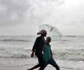
While rain intensity reduced on Tuesday compared to a day ago, affecting mainly districts in the Saurashtra region, administration carried out rescue and relief operations on a large scale, shifting thousands of people to shelters.

The Northern Railways said it has cancelled around 17 trains and diverted around 12 others, while traffic has been suspended at four locations due to waterlogging.

After churning across the Arabian Sea for more than 10 days, Biparjoy made landfall near Jakhau Port in Gujarat on Thursday.

The weather department has said that the skies are expected to be partly cloudy for the next few days in Delhi.

The India Meteorological Department (IMD) seems to have taken a cautious stand over the World Meteorological Organisation's (WMO) projection of a 'poor monsoon' due to a probable 'El Nino' impact. The IMD did not agree with WMO's projections, saying, "El Nino and the progress of monsoon are not mutually exclusive events", and remained non-committal over its earlier projection of a "normal monsoon" for the June-September 2009 season.

Temperatures in 17 locations breached 48 degrees Celsius on Monday, with the relentless heat affecting health and livelihoods across large parts of northwestern and central India.

According to the IMD, a rain event is categorised as a cloudburst if a weather station receives 100 mm of rain in one hour.
After remaining stationary for several hours over the sea, the cyclonic storm 'Phailin' on Thursday intensified, moving slightly northwest and lay centered at about 850 km southeast of Paradip.

Expected to be over 100% of long average period.

The five warmest years in Indian weather history have occurred in the past 14 years -- the others being 2009, 2017 and 2010, in order of intensity.

The Safdarjung Observatory, which provides representative data for the city, recorded a maximum temperature of 40.1 degrees Celsius, which was eight notches more than normal, said Kuldeep Srivastava, the head of the IMD's regional forecasting centre.

The same development would benefit the progress of the north-east monsoon, also known as the 'reverse monsoon'.

It will also be the third cyclone to hit the western state in June since 1965, the meteorological office said.
A mild intensity earthquake with a magnitude of 3.2 on the Richter scale stuck the Koyna dam region in Satara on Monday night, officials said.

Addressing a press conference virtually, India Meteorological Department Director General Mrutyunjay Mohapatra said September was likely to witness normal rainfall in the range of 91-109 per cent of the long period average of 167.9 mm.

The flood-hit religious destinations of Kedarnath, Badrinath, Yamunotri and Gangotri, where rescue operations are underway, would again record heavy rains from Thursday, the India Meteorological Department said on Friday. It also predicted "rather heavy showers" in Hemkund Sahib, another religious destination hit by flash floods and heavy rains, from Wednesday.
Southwest monsoon has furthered advanced into some parts of south Arabian Sea

Seven out of eight women street vendors reported experiencing high blood pressure, while women in the middle age group raised concerns about delays in their menstrual cycles due to the extreme heat.

The IMD defines a normal monsoon as one which delivers between 96 and 104 per cent of the 50-year average rainfall for the season.

India is set to experience extreme heat during the April to June period, with the central and western peninsular parts expected to face the worst impact, the IMD said on Monday as the country prepares for seven-phase general elections from April 19.

India is likely to experience below-normal monsoon rainfall this year, with a 20 per cent chance of drought due to the end of La Nina conditions and the potential for El Nino to take hold, private forecasting agency Skymet Weather said on Monday.
The sluggish southwest monsoon, which yielded one of the driest Junes in a century this year, appears disappointing this month as well.

Heavy waterlogging was witnessed in several towns and cities, while roads were closed in rural areas on Friday morning due a heavy spell.

A sudden downpour in Delhi caught citizens off guard and caused heavy waterlogging and traffic jams on Tuesday while Mumbai breathed a sigh of relief as showers stopped a day after heavy rain brought the metropolis to its knees.
All parts except Northeast may get below-normal rain; govt reiterates assurance on preparations.
With El Nino emerging, forecasts rainfall at 95% of long-period average.

The weather system remained practically stationary during the last six hours and weakened to a depression, and is likely to turn into a well-marked low pressure area during the next 12 hours, it said in a bulletin.

Lakhs of voters will have to bear the searing heat when they step out to exercise their franchise in the second phase of the Lok Sabha elections on Friday.

Of these four flights (except Qatar Airways) returned to Kozhikode airport as the weather condition in Kozhikode gained normalcy.

Very heavy rainfall is likely to occur at one or two places in Kerala on Wednesday.
Market for localised weather forecasting in India offers immense scope; credibility of data a concern.

India's crucial monsoon will be normal this year but with less heavier rains as the weather office on Friday marginally downgraded its earlier forecast.

A cold wave has gripped many parts of north and east India, with Srinagar recording a minimum temperature of minus 5.3 degrees Celsius. Other areas experiencing below-freezing temperatures include Gulmarg, Pahalgam, Konibal, Qazigund, Kupwara, and Kokernag in Kashmir. Himachal Pradesh has issued an orange warning for severe cold wave conditions in several districts. Delhi recorded a minimum temperature of 5.9 degrees Celsius, while Faridkot in Punjab was the coldest in the region at 0 degrees Celsius. Extreme cold conditions also continued in parts of Rajasthan and Jharkhand. The Met office has forecast mainly dry weather until December 26, with the possibility of light snowfall in the higher reaches of Kashmir on the intervening night of December 21-22.
NCDEX benchmark index up 10% over a month, as expectations on sowing gather pace